Australia Fly Guide
NSW · Hawkesbury River

Colo River

Imagery © Esri

info

Before you rely on this page

  • Access here has not been confirmed on the ground — treat every way in as unverified.

The Colo River is a summer bass river in a gorge, and the reason to go is Australian bass taking a surface fly in the last hour of light. It is rugged country almost end to end, and the fishing is best when most people are asleep or sheltering from rain.

The river divides into two parts by how you reach them. The lower reaches have the only vehicle access, off the Putty Road. Everything above is a deep gorge through Wollemi National Park with no road at all, reached on foot by tracks meant for experienced bushwalkers. The local fishing website gives a drop of 214 metres over an 86 kilometre course.

The easy trip is the lower river at dusk. Drive in off the Putty Road, find the water from the card, and fish a popper or a big hopper along the shaded edges from late afternoon into dark. Come back at dawn and fish the same edges again. Between those two windows, fish a streamer or a nymph slow through the deep pools.

The hard trip is the gorge. A local fishing website names the Bob Turner Track, Canoe Creek and Wollemi Creek as walk-ins for experienced bushwalkers, with no mobile phone reception on any of them. Treat it as an overnight walk with a fly rod in the pack, and carry a locator beacon.

No water-specific rule was found for the Colo, so read the current NSW fishing guide before you plan the trip. The same website names Macquarie perch as fully protected here, which is the fishing department's to confirm, so treat one as a fish to release the moment you see what it is.

Watch the forecast for rain, then fish the lower river at dusk.

Water and habitat

The Colo forms where the Wolgan and Capertee rivers meet north of Lithgow and runs east through a deep gorge in Wollemi National Park to join the Hawkesbury. Two more rivers, the Wollangambe and Wollemi Creek, come in along the way and are its other main feeders. It sits almost entirely in rugged country, and the only road access is on the lower reaches.

The local fishing website gives the river a fall of 214 metres over its 86 kilometre course. In our experience bass sit at the heads and tails of the pools, along the shaded rock walls and under overhanging trees, and they move to the edges to feed at dusk and after rain.

The bank cover chart shows how much of the river runs through forest rather than cleared land. In our experience the water tends to run low and clear through summer, the fish are shy in bright light, and a rise after rain that colours the water is what brings them onto the feed.

Cox's gudgeon and sea mullet are the two species recorded here, which suggests the lower river has an estuarine reach and that the small native gudgeon bass and everything else eat is present.

Fish and forage

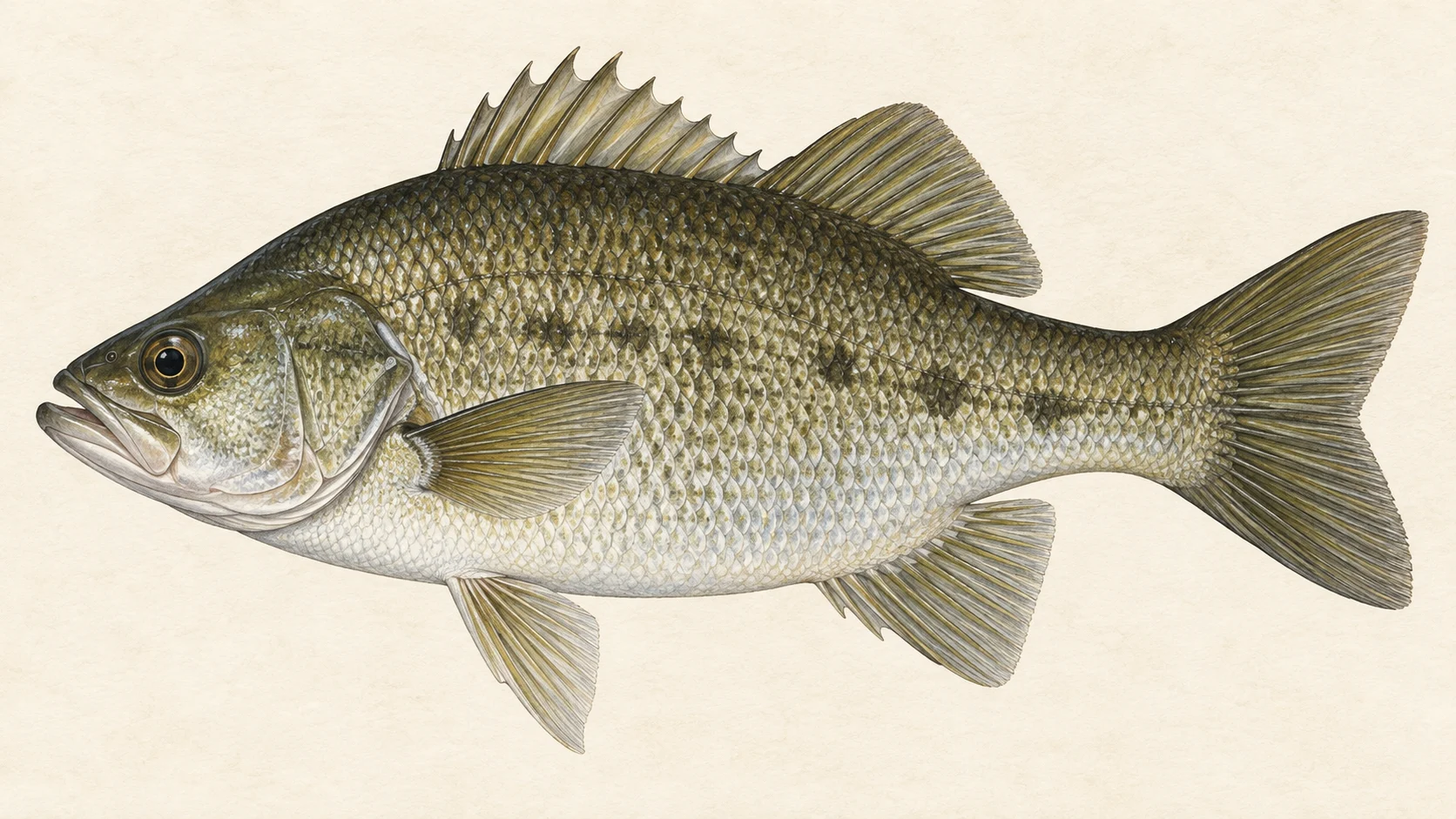
Australian bass are the fish. The river is described mainly as a summer bass fishery, so plan around the warm months. Bass here feed at dusk and dawn and after rain, take surface flies readily in the warm months, and, in our experience, hold in the deeper pools through the middle of the day.

Also present, according to the local fishing website, are eels, eel-tailed catfish, a few trout and some estuary species in the lower river, and Macquarie perch. The website names Macquarie perch as totally protected; that is a matter for the fishing department, so treat any Macquarie perch as a fish to release straight away and confirm its status in the current NSW rules before you go.

Cox's gudgeon, a small native fish, and sea mullet are the species recorded here with high confidence. The gudgeon is the baitfish to copy: a small, dark streamer stripped along the bottom of a pool through the middle of the day is a gudgeon as far as a bass is concerned.

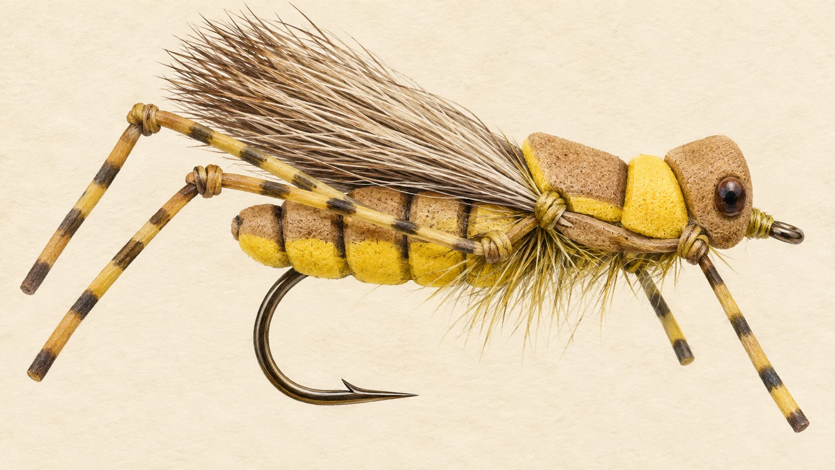
The surface forage in summer is terrestrial. Christmas beetles and grasshoppers fall from the trees and banks on hot days, and a bass that has heard a beetle land will move a long way to get it. That is why the surface fishing is a dusk and dawn affair on the shaded edges, and why a big dry or a popper worked along the trees is the fly of the season.

When to fish it

The Colo is mainly a summer fishery, and the local website's advice on timing is specific: dusk and dawn, or just after heavy rain or during minor flooding. The calendar months follow from that, as a guide's read.

From late spring through summer, fish the last hour of light and the first with a surface fly and the middle of the day with a streamer or a nymph in the deep pools. In our experience the hottest, brightest days are the ones when the dusk bite is strongest and the midday fishing is slowest.

A fresh after rain is, in our experience, the best fishing of the year. When the river rises a little and takes some colour the bass move onto the edges and feed hard, and that is the day to be on the water. A flood is a different thing. Never enter flood water; a gorge river in flood is not fishable and not safe to be near, and treat any creek crossing on a walk-in the same way.

Read the current NSW fishing guide before you plan a trip outside summer.

How to fish it

Fish a six- or seven-weight with a floating line and a short, strong leader for the surface work. At dusk and after rain tie on a surface popper, a big hopper or a Christmas beetle pattern and work it along the shaded edges, under the overhanging trees and along the rock walls. Cast tight to cover, let the fly sit, twitch it, and let it sit again; a bass usually takes on the pause. Keep the rod low and strip-strike, then hold the fish away from the snags it will run for.

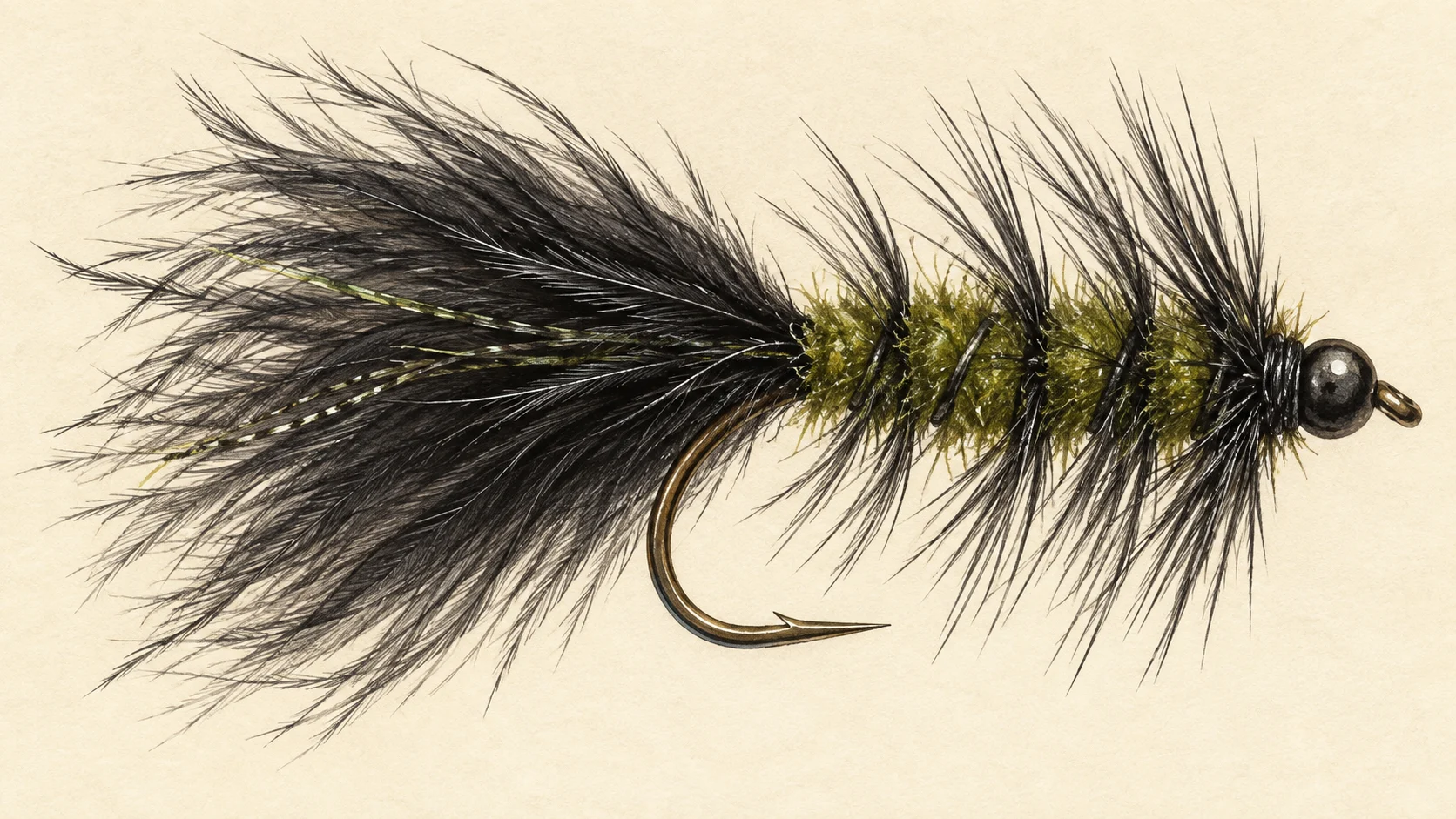
Through the middle of the day switch to streamer fishing in the deep pools. A weighted Woolly Bugger or a small dark gudgeon pattern on a sink-tip, counted down and stripped slowly along the bottom of the pool, will find fish that would never look up in bright light. A weighted nymph fished the same way is the other option the website names.

On the walk-in water, travel light: one rod, one small box with poppers, hoppers, beetles, a few streamers and a few nymphs, and a spare leader. Fish each pool from the tail up so you do not push fish ahead of you, and give the shaded side of the pool your first casts.

Bass are strong fish in a snaggy river, so fish a leader you trust and a net you can land them in. Support the fish in the water while you unhook it and let it swim off under its own power.

Access and safety

The access card shows the ways in and the boat ramp on the lower river. Vehicle access is on the lower reaches off the Putty Road and nowhere else; the local fishing website names it as the only drive-in water on the river.

The walk-ins the website names are the Bob Turner Track, Canoe Creek and Wollemi Creek, all described as for experienced bushwalkers. Those are the website's routes, not a statement that any of them is open to you; check the current national park track conditions and closures before you go. There is no mobile phone reception on those walk-ins, so carry a personal locator beacon, tell someone your plan and your return time, and pack for a night out even on a day trip.

The website's own warning is never to enter flood water. Treat any creek crossing on a walk-in the same way after rain. There is no gauge reading to lean on here, so read the forecast and the river yourself, and if it is rising, stay out.

As on any gorge walk in summer, carry more water than you think you need, wear boots, and fish the edges of the day for your own sake as much as the fishing.

Regulations

No water-specific rule was found for the Colo; read the current NSW guide before you go.

A local fishing website names Macquarie perch in the river as totally protected. That is what the website states, and the fishing department is the authority; confirm it in the current NSW rules, and until you have, release any Macquarie perch immediately.

Before you fish, read the current NSW fishing rules and regulations, the freshwater bag and size limits and the general freshwater closures, and confirm the fishing fee.
3 named access sites

These authority-listed points are separate from the mapped track intersections above. Some were inspected and some are public boat-ramp records; each row says which. A listing does not grant permission across private land, so check closures, signs and gates when you arrive.

Sources: Transport for NSW; NSW Department of Primary Industries and Regional Development.

When things happen

The guide's calendar for this water

When things happen

The year on this water

A year at a glance; check current rules

  • Surface flies at dusk and dawn · Nov to Mar Bass fishing is best at dusk and dawn through the warm months. A popper, a big hopper or a Christmas beetle pattern worked along the edges is the summer fishing here.
  • Beetles and hoppers on the water · Dec to Feb In our experience, Christmas beetles and grasshoppers falling from the banks are what bring bass to the surface in midsummer. Fish the shaded edges and overhanging trees.
  • A fresh after rain · Nov to Mar The fishing is best just after heavy rain or during a minor rise. A fresh switches the bass on; a flood is a river to stay out of, never a river to wade or paddle.

What the record shows

Flows, river gradient, changing water levels, fish surveys and stocking

What the record shows

The fall of the river

Elevation along the river, source to end

Falls 174 m over 103 km, sand bed, floodplain pockets for much of its length.

-4 122 247 0 km from the source: 176 m · falling 0.6 m per km · bedrock, gorge 1 km from the source: 178 m · falling 0.6 m per km · sand, occasional floodplain 2 km from the source: 181 m · falling 0.7 m per km · sand, occasional floodplain 3 km from the source: 176 m · falling 1.4 m per km · sand, occasional floodplain 4 km from the source: 175 m · falling 2 m per km · sand, occasional floodplain 5 km from the source: 173 m · falling 2.7 m per km · sand, occasional floodplain 6 km from the source: 172 m · falling 2.5 m per km · sand, occasional floodplain 7 km from the source: 165 m · falling 2.9 m per km · sand, occasional floodplain 8 km from the source: 162 m · falling 1.8 m per km · sand, occasional floodplain 9 km from the source: 158 m · falling -3.3 m per km · sand, occasional floodplain 10 km from the source: 170 m · falling -5.3 m per km · sand, occasional floodplain 11 km from the source: 148 m · falling -5.1 m per km · sand, occasional floodplain 12 km from the source: 173 m · falling -4.5 m per km · sand, occasional floodplain 13 km from the source: 247 m · falling 1.1 m per km · sand, occasional floodplain 14 km from the source: 194 m · falling 8.2 m per km · sand, occasional floodplain 15 km from the source: 144 m · falling 10.1 m per km · sand, occasional floodplain 16 km from the source: 144 m · falling 10.5 m per km · sand, occasional floodplain 17 km from the source: 146 m · falling 7.8 m per km · sand, occasional floodplain 18 km from the source: 141 m · falling -1.1 m per km · sand, occasional floodplain 19 km from the source: 129 m · falling -3.7 m per km · sand, occasional floodplain 20 km from the source: 131 m · falling -4.6 m per km · sand, occasional floodplain 21 km from the source: 171 m · falling -3.7 m per km · sand, occasional floodplain 22 km from the source: 219 m · falling 0.1 m per km · sand, occasional floodplain 23 km from the source: 129 m · falling 4 m per km · sand, occasional floodplain 24 km from the source: 134 m · falling 3.4 m per km · sand, occasional floodplain 25 km from the source: 140 m · falling 3.3 m per km · sand, occasional floodplain 26 km from the source: 168 m · falling 3.4 m per km · sand, occasional floodplain 27 km from the source: 129 m · falling 1.1 m per km · sand, occasional floodplain 28 km from the source: 144 m · falling 2.6 m per km · sand, occasional floodplain 29 km from the source: 145 m · falling 5.4 m per km · sand, occasional floodplain 30 km from the source: 137 m · falling 7.8 m per km · sand, occasional floodplain 31 km from the source: 123 m · falling 4.6 m per km · sand, occasional floodplain 32 km from the source: 115 m · falling 5 m per km · sand, occasional floodplain 33 km from the source: 98 m · falling 4 m per km · sand, occasional floodplain 34 km from the source: 95 m · falling 2.1 m per km · sand, occasional floodplain 35 km from the source: 156 m · falling 4.1 m per km · sand, occasional floodplain 36 km from the source: 101 m · falling 4.2 m per km · sand, occasional floodplain 37 km from the source: 88 m · falling 4.1 m per km · sand, occasional floodplain 38 km from the source: 85 m · falling 0.5 m per km · sand, occasional floodplain 39 km from the source: 74 m · falling 0.6 m per km · sand, occasional floodplain 40 km from the source: 133 m · falling 0 m per km · sand, occasional floodplain 41 km from the source: 74 m · falling 2.2 m per km · sand, occasional floodplain 42 km from the source: 149 m · falling 5.9 m per km · sand, occasional floodplain 43 km from the source: 63 m · falling 9.3 m per km · sand, occasional floodplain 44 km from the source: 63 m · falling 9.6 m per km · sand, occasional floodplain 45 km from the source: 63 m · falling 7.1 m per km · sand, occasional floodplain 46 km from the source: 61 m · falling 7.3 m per km · sand, occasional floodplain 47 km from the source: 57 m · falling 3.6 m per km · sand, occasional floodplain 48 km from the source: 45 m · falling 3.5 m per km · bedrock, headwater 49 km from the source: 44 m · falling 3 m per km · sand, occasional floodplain 50 km from the source: 44 m · falling 2.6 m per km · sand, occasional floodplain 51 km from the source: 44 m · falling 1.8 m per km · sand, occasional floodplain 52 km from the source: 40 m · falling 1.3 m per km · sand, occasional floodplain 53 km from the source: 36 m · falling 1.4 m per km · sand, occasional floodplain 54 km from the source: 34 m · falling 0.6 m per km · sand, occasional floodplain 55 km from the source: 46 m · falling 0.6 m per km · sand, occasional floodplain 56 km from the source: 36 m · falling 1.1 m per km · sand, occasional floodplain 57 km from the source: 31 m · falling 0.8 m per km · sand, occasional floodplain 58 km from the source: 40 m · falling 1.4 m per km · sand, occasional floodplain 59 km from the source: 35 m · falling 2.4 m per km · sand, occasional floodplain 60 km from the source: 28 m · falling 1.9 m per km · sand, occasional floodplain 61 km from the source: 33 m · falling 2.2 m per km · sand, occasional floodplain 62 km from the source: 22 m · falling 2 m per km · sand, occasional floodplain 63 km from the source: 21 m · falling 1.2 m per km · sand, occasional floodplain 64 km from the source: 27 m · falling 0.8 m per km · sand, discontinuous floodplain 65 km from the source: 21 m · falling 0.9 m per km · sand, discontinuous floodplain 66 km from the source: 27 m · falling 0.6 m per km · sand, discontinuous floodplain 67 km from the source: 20 m · falling 1.3 m per km · sand, discontinuous floodplain 68 km from the source: 20 m · falling 1.4 m per km · sand, discontinuous floodplain 69 km from the source: 18 m · falling 1 m per km · sand, discontinuous floodplain 70 km from the source: 21 m · falling 1.4 m per km · sand, discontinuous floodplain 71 km from the source: 10 m · falling 0.8 m per km · sand, discontinuous floodplain 72 km from the source: 18 m · falling 0.4 m per km · sand, discontinuous floodplain 73 km from the source: 18 m · falling 1 m per km · sand, discontinuous floodplain 74 km from the source: 10 m · falling 1.1 m per km · sand, discontinuous floodplain 75 km from the source: 17 m · falling 1.1 m per km · sand, discontinuous floodplain 76 km from the source: 16 m · falling 1.6 m per km · sand, discontinuous floodplain 77 km from the source: 5 m · falling 1.5 m per km · sand, discontinuous floodplain 78 km from the source: 8 m · falling 0.9 m per km · sand, discontinuous floodplain 79 km from the source: 6 m · falling 0.5 m per km · sand, discontinuous floodplain 80 km from the source: 12 m · falling 0.5 m per km · sand, discontinuous floodplain 81 km from the source: 7 m · falling -0.2 m per km · sand, discontinuous floodplain 82 km from the source: 6 m · falling -0.3 m per km · sand, discontinuous floodplain 83 km from the source: 11 m · falling -0.2 m per km · sand, discontinuous floodplain 84 km from the source: 2 m · falling 0.3 m per km · sand, discontinuous floodplain 85 km from the source: 16 m · falling -0.1 m per km · sand, discontinuous floodplain 86 km from the source: 9 m · falling 0.9 m per km · sand, discontinuous floodplain 87 km from the source: 9 m · falling 0.6 m per km · sand, discontinuous floodplain 88 km from the source: -3 m · falling 0.3 m per km · sand, discontinuous floodplain 89 km from the source: 14 m · falling -0.1 m per km · sand, discontinuous floodplain 90 km from the source: -4 m · falling -0.9 m per km · sand, discontinuous floodplain 91 km from the source: 18 m · falling -0.6 m per km · sand, discontinuous floodplain 92 km from the source: 0 m · falling -0.5 m per km · sand, discontinuous floodplain 93 km from the source: 17 m · falling 0.2 m per km · sand, discontinuous floodplain 94 km from the source: 10 m · falling -0.4 m per km · sand, discontinuous floodplain 95 km from the source: 1 m · falling 0.2 m per km · sand, discontinuous floodplain 96 km from the source: 9 m · falling -0.7 m per km · sand, discontinuous floodplain 97 km from the source: 7 m · falling -0.1 m per km · sand, discontinuous floodplain 98 km from the source: 24 m · falling -0.1 m per km · sand, discontinuous floodplain 99 km from the source: 1 m · falling 0.6 m per km · sand, discontinuous floodplain 100 km from the source: 10 m · falling 0.7 m per km · sand, discontinuous floodplain 101 km from the source: 3 m · falling 0.6 m per km · sand, discontinuous floodplain 102 km from the source: 15 m · falling 1.3 m per km · sand, discontinuous floodplain 103 km from the source: 2 m · falling -0.2 m per km · sand, discontinuous floodplain 0 km 26 km 52 km 77 km 103 km
bedrock · 2% sand · 98%
Headwater
176 m
Outlet
2 m
Typical drop
1.7 m/km
Steepest sampled stretch
10.5 m/km, near 16 km
Hover the profile for the reading at any kilometre.
Source: Geoscience Australia.
Source details and licence

Geoscience Australia — 1 second SRTM-derived DEM-H v1.0 (NCI tile store). Geoscience Australia, 1 second SRTM-derived DEM-H v1.0, © Commonwealth of Australia, CC BY 4.0. retrieved 2026-08-16.

Bed material: NSW Department of Climate Change, Energy, the Environment and Water (Water, Surface Water Science).
Source details and licence

NSW River Styles spatial dataset — geomorphic character and dominant bed material. NSW River Styles spatial dataset, © State Government of NSW and NSW Department of Climate Change, Energy, the Environment and Water 2023. retrieved 2026-08-21.

Gauge pins identify the monitoring stations. The slope shows how steeply the river falls; it does not show rapids or safe wading routes.

The banks, seen from space

Land cover in the 120 m beside the water, Landsat 2023 to 2024 to 2025

0 to 10 km: woody dense 50.4% 0 to 10 km: woody open 48.7% 0 to 10 km: woody sparse 0.3% 0 to 10 km: herbaceous native 0.6% 10 to 20 km: woody dense 43.5% 10 to 20 km: woody open 42.4% 10 to 20 km: woody sparse 5.3% 10 to 20 km: herbaceous native 5.3% 10 to 20 km: cultivated 2.7% 10 to 20 km: bare 0.8% 20 to 30 km: woody dense 52.7% 20 to 30 km: woody open 36.3% 20 to 30 km: woody sparse 3.8% 20 to 30 km: herbaceous native 5.5% 20 to 30 km: cultivated 1.4% 20 to 30 km: bare 0.3% 30 to 40 km: woody dense 65.6% 30 to 40 km: woody open 26.5% 30 to 40 km: woody sparse 4.1% 30 to 40 km: herbaceous native 2.1% 30 to 40 km: cultivated 0.7% 30 to 40 km: bare 0.3% 30 to 40 km: artificial 0.7% 40 to 50 km: woody dense 43.8% 40 to 50 km: woody open 39% 40 to 50 km: woody sparse 7.1% 40 to 50 km: herbaceous native 8.2% 40 to 50 km: cultivated 1.9% 50 to 60 km: woody dense 51.2% 50 to 60 km: woody open 31.9% 50 to 60 km: woody sparse 7.6% 50 to 60 km: herbaceous native 3.4% 50 to 60 km: cultivated 0.8% 50 to 60 km: bare 3.8% 50 to 60 km: artificial 1.3% 60 to 70 km: woody dense 68.8% 60 to 70 km: woody open 15.9% 60 to 70 km: woody sparse 0.6% 60 to 70 km: herbaceous native 1.2% 60 to 70 km: cultivated 9.4% 60 to 70 km: bare 2.9% 60 to 70 km: artificial 1.2% 70 to 80 km: woody dense 40.9% 70 to 80 km: woody open 21.8% 70 to 80 km: woody sparse 1.1% 70 to 80 km: herbaceous native 4.1% 70 to 80 km: cultivated 29.5% 70 to 80 km: bare 2.6% 80 to 90 km: woody dense 62.7% 80 to 90 km: woody open 21.2% 80 to 90 km: woody sparse 1.2% 80 to 90 km: herbaceous native 2.5% 80 to 90 km: cultivated 12.4% 90 to 100 km: woody dense 52.9% 90 to 100 km: woody open 33.9% 90 to 100 km: woody sparse 0.4% 90 to 100 km: herbaceous native 2.4% 90 to 100 km: cultivated 10.4% 100 to 103 km: woody dense 21.8% 100 to 103 km: woody open 30.8% 100 to 103 km: herbaceous native 7.7% 100 to 103 km: cultivated 39.7% 0 km 20 km 40 km 60 km 80 km 100 km
dense forest open woodland scattered trees and scrub native grass and heath farmed or cleared bare ground lake
Along the river itself about 88% of the bank is under trees, 4% is native grass or heath and 8% is farmed. The most wooded stretch is 0 to 10 km from the source; the most open is 100 to 103 km. A satellite reads the canopy, not the ground beneath it, so treat this as a read of the country, not a survey of every bank.
Source: Geoscience Australia / Digital Earth Australia.
Source details and licence

DEA Land Cover (Landsat) — Level 4 classification, continental mosaics. © Commonwealth of Australia (Geoscience Australia). DEA Land Cover (Landsat), Digital Earth Australia. retrieved 2026-08-19.

How well this water has been surveyed

2 capture records, 1 decade of 1 on file

0 1 2 2000s: 2 capture records 2000s
electrofishing (backpack), 2 records
Capture records by decade — electrofishing, netting, trapping and rotenone surveys only; a sighting, an eDNA water sample or a stocking release is not a capture and is not counted here. A record is not an abundance estimate, and a decade with no bar is a decade with no capture survey on file, not evidence the water was empty.
Source: Atlas of Living Australia.
Source details and licence

Atlas of Living Australia — freshwater fish occurrence records (open licences, with coordinates). Occurrence records from the Atlas of Living Australia and its contributing datasets, including the Victorian Biodiversity Atlas, NSW BioNet Atlas, Sustainable Rivers Audit, Murray-Darling Basin fish monitoring programs, OZCAM museum collections and iNaturalist Australia. Each record carries its own licence and originating dataset. retrieved 2026-08-13.

Conditions

What the gauges say

Check the water operator or jurisdiction authority for current conditions, and read the water yourself when you arrive.

Questions anglers ask

Where should I start on the Colo?

On the lower reaches, where the only vehicle access is, off the Putty Road. The access card shows the ways in and the boat ramp. Fish the last hour of light with a surface fly and you will have seen the river at its best.

When is the best time to fish it?

Summer, at dusk and dawn, and just after heavy rain or during a minor rise. The Colo is mainly a summer bass fishery. No water-specific rule was found for the Colo, so read the current NSW guide before you plan the trip.

Can I walk in to the gorge?

Only if you are an experienced bushwalker. The walk-ins a local fishing website names are the Bob Turner Track, Canoe Creek and Wollemi Creek, all described as for experienced walkers, and there is no mobile phone reception on them. Carry a personal locator beacon and tell someone your plan.

What else is in the river besides bass?

Eels, eel-tailed catfish, a few trout and some estuary species in the lower river, and Macquarie perch, which the same website names as fully protected. Treat any Macquarie perch as a fish to release straight away and confirm its status in the current NSW rules.

Is it safe to fish after a flood?

In our experience a minor rise is the best fishing of the year; a flood is not fishing at all. Never enter flood water on foot, in a canoe or in a car. Wait for the river to drop and clear before you go near it.

Behind this page