Australia Fly Guide
NSW · Monaro

Eucumbene River

Imagery © Esri

There is a moment in late April, high on the Monaro, when the wind swings to the south and you can smell snow on it before there is any snow to see. Out in Lake Eucumbene the big browns feel it too, and turn upstream, and within a few weeks fish that have spent years growing fat in a still water are pushing up a river you could throw a stone across. That run is why anglers have driven five hours from Sydney for as long as there has been a dam. It made the Eucumbene famous, and it wrote the tightest rulebook on any trout stream in the state.

But the run is a few weeks. The river is a whole year, and most of it is better than its reputation. Understand the shape of it first: the river rises on the snow plains above Kiandra, runs down into Lake Eucumbene, disappears for thirty-odd kilometres of drowned valley, and comes out below the wall as a different river with a different rulebook. That gives you three stretches and three trips.

The river most people mean is the middle one, from the highway bridge at Kiandra down to the lake. Below the old goldfield it drops into a boulder gorge, comes out into runs and pools at Denison, and stretches into long clear glides to Providence Portal. From Christmas to April it is hopper water of the first order with almost nobody on it. From late April it is the run, and the rules tighten with it. This whole stretch, and the headwaters above it, is fly-and-lure-only spawning-stream water that closes after the June long weekend until October.

The headwaters above Kiandra are the small-stream trip: a tussock creek in the snow country where wild fish rise to a size fourteen dry, fished on your knees in January with the plain to yourself.

The tailwater below the wall is the trip for being left alone: a small green river through heavy timber that most people drive straight past on the way to Jindabyne, in order on opening weekend while the water above the lake is still high and cold, and outside the fly-and-lure listing.

Seventy years of the Providence gauge draw the river's year, with the wadeable band shaded, so you can see which weeks the run water is usually in order before you pack the car. Open the stretch, not this page, and check the current NSW closure notice for the dates.

Choose your stretch

Numbered from the source; each opens its own guide

Choose your stretch of the Eucumbene River

  1. Stretch 1 · 12.7 km Headwaters to Kiandra The Eucumbene as a tussock creek on the snow plains above Kiandra — small wild trout, a dry fly you can see, and the Snowy Mountains Highway for company. Rainbow Trout
  2. Stretch 2 · 15.6 km Kiandra to Lake Eucumbene The Eucumbene everyone means — the gorge below Kiandra, the runs and pools at Denison, the long glides to Providence Portal, the autumn run of lake browns, and a gauge that has watched it all since 1956. Rainbow TroutLive gauge
  3. Stretch 3 · 26.6 km Eucumbene Dam to Lake Jindabyne The Eucumbene below the wall — a small tailwater dropping off the dam through timbered bedrock country, easing across Nimmo Plain, and drowning again in Lake Jindabyne. Different water, different rules, nobody about. Rainbow Trout

River map

Numbered from the source; a name is a link where that water has a page

River map of Eucumbene River

Snowy River James Creek Rocky Plains Creek Little Swamp Creek Bundara Creek Pollocks Gully Bullocks Head Creek Dog Trap Creek Bills Creek Bough Creek Racecourse Creek Snowy Gap Rivulet Kalkite Creek Giandarra Gully Cemetery Creek Black Walters Creek Bog Hole Creek Burns Creek Swamp Creek Three Mile Creek Whipstick Gully Tabletop Creek Hayes Gully Gang Gang Creek Lucas Creek Andys Creek Chance Creek Big Tolbar Creek Hughes Creek Garden Gully Four Mile Creek Yans Gully Taylors Creek Alpine Creek Charcoal Creek Rocky Plain Creek Camping Creek Frying Pan Creek Little Plain Creek Long Plain Creek Pipeclay Creek Lake Eucumbene Lake Jindabyne Headwaters to Kiandra Kiandra to Lake Eucumbene Eucumbene Dam to Lake Jindabyne Eucumbene River Snowy River open_in_new James Creek Rocky Plains Creek Little Swamp Creek Bundara Creek Pollocks Gully Bullocks Head Creek Dog Trap Creek Bills Creek Bough Creek Racecourse Creek Snowy Gap Rivulet Kalkite Creek Giandarra Gully Cemetery Creek Black Walters Creek Bog Hole Creek Burns Creek Swamp Creek Three Mile Creek Whipstick Gully Tabletop Creek Hayes Gully Gang Gang Creek Lucas Creek Andys Creek Chance Creek Big Tolbar Creek Hughes Creek Garden Gully Four Mile Creek Yans Gully Taylors Creek Alpine Creek Charcoal Creek Rocky Plain Creek Camping Creek Frying Pan Creek Little Plain Creek Long Plain Creek Pipeclay Creek 1 Source 1. Source 2 Kiandra 2. Kiandra 3 Into Lake Eucumbene 3. Into Lake Eucumbene 4 Lake Eucumbene wall 4. Lake Eucumbene wall 5 Into Lake Jindabyne 5. Into Lake Jindabyne

When things happen

The guide's calendar for this water

When things happen

The year on this water

A guide's calendar, not a rulebook

  • Spring melt · Aug to Nov The gauge runs high and cold above the lake. Nymphs take fish; dries mostly do not.
  • Rainbows in the spring water · Oct to Nov Rainbows push up out of the lake as the season opens and the melt eases.
  • Caddis and mayfly · Nov to Apr The bread and butter of the runs. An Elk Hair Caddis in the evening riffles.
  • Hoppers on the tussock · Dec to Apr From Christmas until the frosts, the daytime fly along any grassy bank.
  • Dry-fly prime · Dec to Apr Low, clear, warm. The river at its best and least crowded.
  • Lake browns run · Apr to Jun Big fish out of the lake, nosing up past Providence and into Denison. The rules tighten with them; see Regulations.

Water and habitat

The Eucumbene rises on the snow plains north of Kiandra, fourteen hundred metres up, and falls through country that changes its character three times before it is done. The drawings below show each change without a paragraph of numbers. The fall of the river has a long flat shelf in the middle where the water sits in the lake. The bank survey from space shows tussock and heath along the top, forest through the gorge, and the paddocks and timber of the Monaro along the bottom.

Headwaters to Kiandra is the top of it: a creek in alpine grass beside the Snowy Mountains Highway, small wild fish, open to the sky.

Kiandra to Lake Eucumbene is the river most people mean. Below the old goldfield the water drops into a boulder gorge, comes out into runs and pools around Denison, then opens into the long glides and riffles that carry it to Providence Portal and the lake. The gauge sits on this stretch and its record goes back to the 1950s.

Then the river disappears into Lake Eucumbene for thirty-odd kilometres of drowned valley, and comes out again below the wall as a different animal.

Eucumbene Dam to Lake Jindabyne is that animal: a tailwater dropping steeply off the dam, then a confined bedrock river through heavy timber, easing across Nimmo Plain before it drowns a second time in Lake Jindabyne.

When to fish it

Fish the stretch in front of you, and read its page before you pack, because the rules and the timing differ above and below the wall. What holds for the whole river is the shape of the year the gauge draws: a spring melt that keeps the river high and cold into November, a long settled summer and autumn when it drops into wadeable water, and the run. The calendar below lays it out month by month.

Snow country closes itself. Above the lake the river shuts by law after the June long weekend and does not open until October, and by then the highway can still be white.

Fish and forage

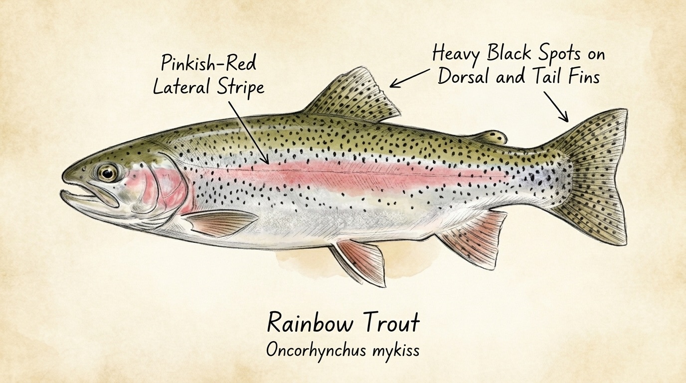
Brown trout and rainbow trout. The browns are the story, resident fish through the summer and the lake fish on top of them in autumn, and they can be big. The rainbows come up in the spring water. This is not a stocked river: the fish in it were born in it or walked up from the lake, which is the whole point.

What they eat is what the country offers. Caddis and mayfly in the runs, and from Christmas until the frosts return, grasshoppers off the tussock in numbers that make a hopper the daytime fly across most of the river.

Access and safety

The Snowy Mountains Highway follows the top of the river and crosses it at Kiandra. Below that the way in is on foot along fire trails through Kosciuszko National Park, then off the lake tracks around Denison and Providence. Below the wall the river runs through a mix of park and grazing country around Nimmo Plain, where a fence and a gate are the answer for the day. The stretch pages name the ways in. NSW DPIRD lists nineteen inspected angler access sites along this river, and they are pinned further down this page.

This is alpine country at every stretch. Weather arrives fast and from the south. A summer afternoon at Kiandra can drop to sleet in an hour, and in the gorge a fall is a long walk from anyone. Carry more than you think you need and leave before the light does.

Regulations

NSW DPIRD classifies the Eucumbene above the dam wall of Lake Eucumbene, including its creeks and tributaries and Providence Portal, as artificial fly and lure water and as a trout spawning stream. The two stretch pages above the lake state what that means in practice. Below the wall those listings do not apply, and that page says what does.

Check the current NSW trout fishing closure notification and the Snowy trout waters guide before you go. The season is set by moveable long weekends and this page does not carry the dates.
What the record shows

The gauge, the fall of the river and the banks, drawn rather than described

What the record shows

The river's year

Daily flow at Eucumbene River @providence 2, every year 1956 to 2026

0.2 0.5 1 2 5 10 20 wadeable drift ceiling Jan Feb Mar Apr May Jun Jul Aug Sep Oct Nov Dec m³/s
71 years of the gauge, week by week. The dark band is the middle half of all years, the pale band nine years in ten, the line the median. The shaded strip is the band the river sits in about half of all days, the flows most anglers here would call wadeable: a guide's rule of thumb, not a measured limit. In a typical year the river sits in it from late October to early March, and runs too high to wade from late June to late October. Median flow peaks in early September and bottoms out in mid March.

How often it runs this high

18,089 days at Eucumbene River @providence 2, 1956 to 2026

0.2 0.5 1 2 5 10 20 50 wadeable 0.588 to 4.514 m³/s drift ceiling 9.095 m³/s 0% of days 25% of days 50% of days 75% of days 100% of days m³/s
Read it left to right: the river runs above the flow on the left edge almost never, and above the flow on the right edge almost always. Half of all days sit below 2.6 m³/s. The shaded band is where it sits about half the time, the flows most anglers here would call wadeable; it runs above that one day in three and above the drift ceiling about one day in seven. The bands are a guide's rule of thumb drawn from the record, not a measured limit: read the river when you get there.

The fall of the river

Elevation along the river, source to end, with the riverbed beneath

Lake Eucumbene, 28.2 to 60.1 km, about 1154 m Lake Eucumbene Lake Jindabyne, 87.5 to 96.5 km, about 904 m Lake Jindabyne 0 km from the source: 1402 m · falling 3.4 m per km · gravel 1 km from the source: 1393 m · falling 4.2 m per km · gravel 2 km from the source: 1386 m · falling 4.5 m per km · gravel 3 km from the source: 1379 m · falling 4.8 m per km · gravel 4 km from the source: 1375 m · falling 5.1 m per km · gravel 5 km from the source: 1373 m · falling 4.5 m per km · gravel 6 km from the source: 1366 m · falling 4 m per km · gravel 7 km from the source: 1362 m · falling 3.6 m per km · gravel 8 km from the source: 1358 m · falling 3.6 m per km · gravel 9 km from the source: 1358 m · falling 3.8 m per km · gravel 10 km from the source: 1355 m · falling 4.4 m per km · gravel 11 km from the source: 1351 m · falling 5.2 m per km · gravel 12 km from the source: 1340 m · falling 5.9 m per km · gravel 13 km from the source: 1337 m · falling 6.3 m per km · gravel 14 km from the source: 1329 m · falling 6.8 m per km · gravel, discontinuous floodplain 15 km from the source: 1323 m · falling 6.8 m per km · gravel, discontinuous floodplain 16 km from the source: 1315 m · falling 6.9 m per km · gravel, discontinuous floodplain 17 km from the source: 1310 m · falling 7.3 m per km · gravel, discontinuous floodplain 18 km from the source: 1298 m · falling 6.6 m per km · gravel, discontinuous floodplain 19 km from the source: 1297 m · falling 6.6 m per km · gravel, discontinuous floodplain 20 km from the source: 1285 m · falling 7.4 m per km · gravel, discontinuous floodplain 21 km from the source: 1279 m · falling 8.6 m per km · gravel, discontinuous floodplain 22 km from the source: 1283 m · falling 11.3 m per km · gravel, discontinuous floodplain 23 km from the source: 1266 m · falling 14.7 m per km · bedrock, gorge 24 km from the source: 1243 m · falling 16.8 m per km · bedrock, gorge 25 km from the source: 1226 m · falling 18 m per km · bedrock, gorge 26 km from the source: 1198 m · falling 17.6 m per km · bedrock, gorge 27 km from the source: 1184 m · falling 14.8 m per km · bedrock, gorge 28 km from the source: 1170 m · falling 11.5 m per km · bedrock, gorge 29 km from the source: 1159 m · falling 8.1 m per km · water storage 30 km from the source: 1154 m · falling 4.8 m per km · water storage 31 km from the source: 1154 m · falling 2.5 m per km · water storage 32 km from the source: 1154 m · falling 1.1 m per km · water storage 33 km from the source: 1154 m · falling 0.3 m per km · water storage 34 km from the source: 1154 m · falling 0 m per km · water storage 35 km from the source: 1154 m · falling 0.1 m per km · water storage 36 km from the source: 1153 m · falling 0.1 m per km · water storage 37 km from the source: 1154 m · falling 0.1 m per km · water storage 38 km from the source: 1154 m · falling 0.1 m per km · water storage 39 km from the source: 1152 m · falling 0 m per km · water storage 40 km from the source: 1154 m · falling -0.1 m per km · water storage 41 km from the source: 1154 m · falling -0.1 m per km · water storage 42 km from the source: 1154 m · falling -0.1 m per km · water storage 43 km from the source: 1154 m · falling -0.1 m per km · water storage 44 km from the source: 1154 m · falling 0 m per km · water storage 45 km from the source: 1154 m · falling 0 m per km · water storage 46 km from the source: 1154 m · falling 0 m per km · water storage 47 km from the source: 1154 m · falling 0 m per km · water storage 48 km from the source: 1154 m · falling 0 m per km · water storage 49 km from the source: 1154 m · falling 0 m per km · water storage 50 km from the source: 1154 m · falling 0 m per km · water storage 51 km from the source: 1154 m · falling 0 m per km · water storage 52 km from the source: 1154 m · falling 0 m per km · water storage 53 km from the source: 1154 m · falling 0 m per km · water storage 54 km from the source: 1154 m · falling 0 m per km · water storage 55 km from the source: 1154 m · falling 0 m per km · water storage 56 km from the source: 1154 m · falling 0.6 m per km · water storage 57 km from the source: 1154 m · falling 5.3 m per km · water storage 58 km from the source: 1154 m · falling 10.2 m per km · water storage 59 km from the source: 1154 m · falling 15.5 m per km · water storage 60 km from the source: 1142 m · falling 20.2 m per km · water storage 61 km from the source: 1059 m · falling 20.3 m per km · sand, occasional floodplain 62 km from the source: 1057 m · falling 15.8 m per km · bedrock, gorge 63 km from the source: 1048 m · falling 11.3 m per km · bedrock, gorge 64 km from the source: 1048 m · falling 6.1 m per km · bedrock, gorge 65 km from the source: 1045 m · falling 1.7 m per km · gravel 66 km from the source: 1051 m · falling 1.9 m per km · gravel, discontinuous floodplain 67 km from the source: 1042 m · falling 2.2 m per km · gravel, discontinuous floodplain 68 km from the source: 1046 m · falling 2.7 m per km · gravel, discontinuous floodplain 69 km from the source: 1038 m · falling 3.2 m per km · gravel, discontinuous floodplain 70 km from the source: 1033 m · falling 3.7 m per km · gravel, discontinuous floodplain 71 km from the source: 1031 m · falling 3.9 m per km · gravel, discontinuous floodplain 72 km from the source: 1029 m · falling 4.9 m per km · gravel, discontinuous floodplain 73 km from the source: 1028 m · falling 5.8 m per km · gravel, discontinuous floodplain 74 km from the source: 1016 m · falling 6.8 m per km · gravel, discontinuous floodplain 75 km from the source: 1008 m · falling 7.4 m per km · bedrock, gorge 76 km from the source: 998 m · falling 7.7 m per km · bedrock, gorge 77 km from the source: 992 m · falling 8.5 m per km · bedrock, gorge 78 km from the source: 987 m · falling 9.1 m per km · bedrock, gorge 79 km from the source: 978 m · falling 9.7 m per km · bedrock, gorge 80 km from the source: 969 m · falling 10 m per km · bedrock, gorge 81 km from the source: 947 m · falling 9.7 m per km · bedrock, gorge 82 km from the source: 939 m · falling 8.2 m per km · sand, occasional floodplain 83 km from the source: 937 m · falling 6.6 m per km · sand, occasional floodplain 84 km from the source: 933 m · falling 5.3 m per km · bedrock, gorge 85 km from the source: 925 m · falling 4.6 m per km · bedrock, gorge 86 km from the source: 923 m · falling 4.6 m per km · bedrock, gorge 87 km from the source: 921 m · falling 4.8 m per km · bedrock, gorge 88 km from the source: 917 m · falling 4.7 m per km · water storage 89 km from the source: 903 m · falling 4 m per km · water storage 90 km from the source: 902 m · falling 2.8 m per km · water storage 91 km from the source: 901 m · falling 1.7 m per km · water storage 92 km from the source: 902 m · falling 0.7 m per km · water storage 93 km from the source: 902 m · falling 0 m per km · water storage 94 km from the source: 902 m · falling -0.1 m per km · water storage 95 km from the source: 902 m · falling 0 m per km · water storage 96 km from the source: 902 m · falling 0 m per km · water storage 0 to 23 km: gravel bed 23 to 29 km: bedrock bed 61 to 62 km: sand bed 62 to 65 km: bedrock bed 65 to 75 km: gravel bed 75 to 82 km: bedrock bed 82 to 84 km: sand bed 84 to 88 km: bedrock bed 0 km 20 km 40 km 60 km 80 km
bedrock gravel and cobble sand
Falls from about 1402 m to 902 m over 96 km. Steepest around the 61 km mark, dropping about 20 m for every km. The flat shelves are the lakes the river runs through: Lake Eucumbene and Lake Jindabyne. Where the bed has been surveyed it is gravel for about 33 km, bedrock for about 20 km and sand for about 3 km. Hover the profile for the reading at any kilometre.

The banks, seen from space

Land cover in the 120 m beside the water, Landsat 2023 to 2024 to 2025

Lake Eucumbene: the river runs through a lake here, so there is no riverbank to read Lake Jindabyne: the river runs through a lake here, so there is no riverbank to read 0 to 5 km: woody open 51.9% 0 to 5 km: herbaceous native 48.1% 5 to 10 km: woody open 6.9% 5 to 10 km: woody sparse 3.1% 5 to 10 km: herbaceous native 88.7% 5 to 10 km: cultivated 1.3% 10 to 15 km: woody open 17.5% 10 to 15 km: woody sparse 6.9% 10 to 15 km: herbaceous native 75.6% 15 to 20 km: woody open 64.4% 15 to 20 km: herbaceous native 35.6% 20 to 25 km: woody open 59.3% 20 to 25 km: woody sparse 6.9% 20 to 25 km: herbaceous native 33.8% 25 to 30 km: woody open 74.3% 25 to 30 km: woody sparse 7.2% 25 to 30 km: herbaceous native 13.2% 25 to 30 km: cultivated 5.3% 60 to 65 km: woody open 71.2% 60 to 65 km: woody sparse 6.3% 60 to 65 km: herbaceous native 14.4% 60 to 65 km: cultivated 3.1% 60 to 65 km: bare 5% 65 to 70 km: woody open 60.5% 65 to 70 km: woody sparse 3.8% 65 to 70 km: herbaceous native 26.3% 65 to 70 km: cultivated 9.4% 70 to 75 km: woody open 78.6% 70 to 75 km: woody sparse 3.8% 70 to 75 km: herbaceous native 13.8% 70 to 75 km: cultivated 3.8% 75 to 80 km: woody open 95% 75 to 80 km: woody sparse 1.9% 75 to 80 km: herbaceous native 3.1% 80 to 85 km: woody open 92.5% 80 to 85 km: woody sparse 5.6% 80 to 85 km: herbaceous native 1.9% Lake Eucumbene Lake Jindabyne 0 km 20 km 40 km 60 km 80 km
dense trees open or scattered trees native grass and heath farmed or cleared bare ground
Along the river itself about 64% of the bank is under trees, 33% is native grass or heath and 3% is farmed. The most wooded stretch is 80 to 85 km from the source; the most open is 5 to 10 km. A satellite reads the canopy, not the ground beneath it, so treat this as a read of the country, not a survey of every bank.
park

Kosciuszko National Park sets the rules here

Three things hold on every NSW national park water on this guide, not just this one: a track can close at short notice for weather, fire or maintenance with no warning on this page; some areas carry special-area rules that aren't always published anywhere online; and a locked gate is the answer for the day, not an obstacle to find a way around. Check current alerts and closures with NPWS before you go — everything below describes the country, not a guarantee of what you'll find when you get there.

Questions anglers ask

Which stretch should I fish?

Open the stretch, not this page. If you want a small dry fly and a creek you can wade in runners, go to the headwaters above Kiandra. If you want the river everyone means when they say "the Eucumbene", the runs and glides between Kiandra and the lake, go to Kiandra to Lake Eucumbene. If you want to be left alone, go below the wall.

When is the famous spawn run?

Autumn into early winter, on the water above the lake, and the rules tighten as it happens. From the start of May the take on the spawning water drops to one fish and a big one, and the river closes altogether after the June long weekend until October. The dates move with the public holidays, so the stretch page tells you the shape of it and the NSW closure notice gives you the day.

Is the whole river fly and lure only?

No. NSW DPIRD lists the Eucumbene above the dam wall, with its creeks and tributaries and Providence Portal, as artificial fly and lure water and as a trout spawning stream. Below the wall that listing does not reach. The tailwater page says what applies there.

Where is the gauge, and what is it good for?

At Providence, just above where the river meets the lake. It has been recording daily since the 1950s, which is why this page can draw the river's year for you rather than guess at it. It reads the lower run water well and the headwaters loosely. Below the wall it tells you nothing at all.

What about Lake Eucumbene and Lake Jindabyne?

They are other waters with their own pages, and they sit on the map here as the two lakes the river runs through. This page is the river.

Behind this page

Listed access

Where the authority put a pin

Flying Fox

-35.93705, 148.57082 · listed by DPIRD

View on map

Four Mile Trail

-35.91954, 148.54063 · listed by DPIRD

View on map

Four Mile Trail Nth

-35.91653, 148.53793 · listed by DPIRD

View on map

Gooandra Track

-35.81918, 148.50348 · listed by DPIRD

View on map

Kiandra 1

-35.88626, 148.51548 · listed by DPIRD

View on map

Kiandra 2

-35.88974, 148.51624 · listed by DPIRD

View on map

Kiandra 3

-35.89171, 148.51368 · listed by DPIRD

View on map

Kiandra Bridge

-35.88497, 148.5144 · listed by DPIRD

View on map

Locked Gate

-35.8726, 148.5035 · listed by DPIRD

View on map

Nimmo Camp

-36.18284, 148.6356 · listed by DPIRD

View on map

Nimmo TSR Nth

-36.18256, 148.63343 · listed by DPIRD

View on map

Nimmo TSR Sth

-36.18585, 148.63603 · listed by DPIRD

View on map

Nungar Fire trail

-35.86678, 148.50029 · listed by DPIRD

View on map

Pretty Pot Trail

-36.2535, 148.62015 · listed by DPIRD

View on map

Sawyers Hill

-35.9098, 148.5156 · listed by DPIRD

View on map

Snowy Mountains Hwy

-35.80093, 148.49713 · listed by DPIRD

View on map

Suicide hole carpark

-35.89262, 148.51147 · listed by DPIRD

View on map

They put in a gate

-35.86899, 148.50041 · listed by DPIRD

View on map

Upstream of Kiandra Bridge

-35.88138, 148.51455 · listed by DPIRD

View on map

A listed pin is not a right of entry. Tenure and conditions can change; check the current authority page before you go.

Sources

  1. 1 NSW DPIRD fishing guides, stocking resources and trout waters Primefacts, NSW Department of Primary Industries and Regional Development, Creative Commons Attribution 4.0, retrieved 2026-08-20.
  2. 2 Atlas of Living Australia — freshwater fish occurrence records (open licences, with coordinates), Creative Commons (open licences only: CC0, CC-BY, CC-BY 3.0 Au, CC-BY 4.0 Int, CC-BY-SA 4.0 Int), retrieved 2026-08-13.
  3. 3 Geofabric v3.x — national stream topology, Bureau of Meteorology, Creative Commons Attribution 4.0 International, retrieved 2026-08-13.
  4. 4 Bureau of Meteorology — Water Data Online daily-mean values (bound stations), Creative Commons Attribution 4.0 International, retrieved 2026-08-15.
  5. 5 Geoscience Australia — 1 second SRTM-derived DEM-H v1.0 (NCI tile store), Creative Commons Attribution 4.0 International, retrieved 2026-08-16.
  6. 6 NSW angler access sites — inland and tidal inspected-site layers, NSW Department of Primary Industries and Regional Development, retrieved 2026-08-17.
  7. 7 DEA Land Cover (Landsat) — Level 4 classification, continental mosaics, Geoscience Australia / Digital Earth Australia, Creative Commons Attribution 4.0 International, retrieved 2026-08-19.
  8. 8 DEA Water Observations Statistics (Landsat) — all-time water frequency, Geoscience Australia / Digital Earth Australia, Creative Commons Attribution 4.0 International, retrieved 2026-08-22.
  9. 9 NSW DPIRD Recreational Fishing Guides — regional PDFs, NSW Department of Primary Industries and Regional Development, CC BY 4.0, retrieved 2026-08-23.
  10. 10 Geofabric v3.x — river regions (RiverRegion), national, Bureau of Meteorology, Creative Commons Attribution 4.0 International, retrieved 2026-08-23.